
CF09 - Navarrete - Nájera - 16,9 km
Distance17 Km.Related packages


Leaving Navarrete: First Steps towards Nájera
Upon leaving Navarrete, the pilgrim encounters the municipal cemetery, notable for its decorated portal and several capitals illustrating scenes from the everyday life of medieval pilgrims. These details provide a first glimpse into the history surrounding the Camino de Santiago on this stage.
The Camino towards Nájera: Between Mountains and Legends
After walking approximately five kilometres from Navarrete, the dirt path leading to Nájera becomes visible. To the left, Mount San Lorenzo, the highest peak in La Rioja, stands out in the landscape. In the distance, the legendary Poyo Roldán, an isolated hill, evokes medieval legends, such as the famous battle between the giant Ferragut and Roland, the knight in the service of Charlemagne.
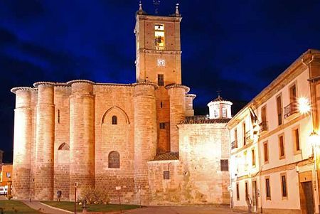
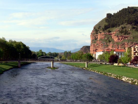
Entering Nájera: The Najerilla River and its History
To reach the old town of Nájera, the pilgrim must descend San Fernando Street, until they find the Najerilla River and cross the bridge, which, according to tradition, was also built by San Juan de Ortega. Nájera, which was the most important political centre during the Reconquista between the years 918 and 1076, was the capital of the Kingdom of Pamplona-Nájera.
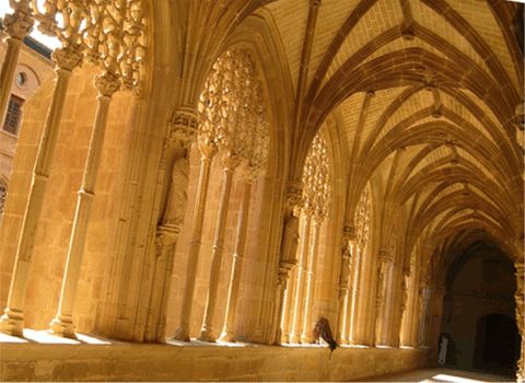
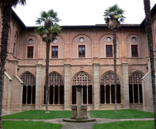
The Monastery of Santa María la Real: A Must-See Stop
A must-visit in Nájera is the Monastery of Santa María la Real, a place of great historical and spiritual significance on the Camino de Santiago. Here rest many of the kings and nobles linked to the dynasty that ruled the Kingdom of Pamplona-Nájera. Moreover, the monastery has always been a refuge for pilgrims, providing rest and shelter to those travelling the routes towards Santiago de Compostela.
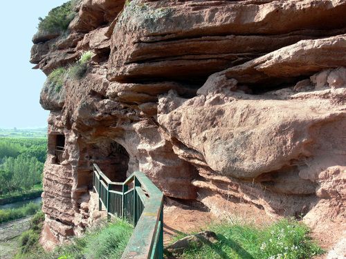
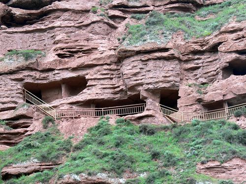
The Rock Complex of Nájera: Vestiges of a Distant Past
An impressive site in Nájera is its rock complex, located at the foot of the mountains that protect the city. This group of artificial caves dates back to the Dark Ages, when Celtic invasions created an atmosphere of social insecurity. These caves are witnesses to the life of the region's inhabitants during those difficult times.
Stages
- CF01 - Saint Jean de Pied de Port - Roncesvalles - 21 km
- CF02 - Roncesvalles - Zubiri - 22 km
- CF03 - Zubiri - Pamplona - 20 km
- CF04 - Pamplona - Puente la Reina - 19 km
- CF05 - Puente la Reina - Estella - 19,7 km
- CF06 - Estella - Los Arcos - 20,6 km
- CF07 - Los Arcos - Viana - 18 km
- CF08 - Viana - Navarrete - 22,3 km
- CF09 - Navarrete - Nájera - 16,9 km
- CF10 - Nájera - Santo Domingo de la Calzada - 21 km
- CF11 - Santo Domingo de la Calzada - Belorado - 22,7 km
- CF12 - Belorado - San Juan de Ortega - 24 km
- CF13 - San Juan de Ortega - Burgos - 27,6 km
- CF14 - Burgos - Hornillos del Camino - 18,3 km
- CF15 - Hornillos del Camino - Castrojeriz - 20,40 km
- CF16 - Castrojeriz - Frómista - 24,90 km
- CF17 - Frómista - Carrión de los Condes - 19,2 km
- CF18 - Carrión de los Condes - Lédigos - 23,40 km
- CF19 - Lédigos - Sahagún - 17,10 km
- CF20 - Sahagún - El Burgo Ranero - 17,9 km
- CF21 - El Burgo Ranero - Mansilla de las Mulas - 18,7 km
- CF22 - Mansilla de las Mulas - León - 18,4 km
- CF23 - León - Villadangos del Páramo - 21,8 km
- CF24 - Villadangos del Páramo - Astorga - 26 km
- CF25 - Astorga - Rabanal del Camino - 20,6 km
- CF26 - Rabanal del Camino - Molinaseca - 24,7 km
- CF27 - Molinaseca - Villafranca del Bierzo - 30,5 km
- CF28 - Villafranca del Bierzo - O Cebreiro - 30 km
- CF29 - O Cebreiro - Triacastela - 22,9 km
- CF30 - Triacastela - Sarria - 22 km
- CF31 - Sarria - Portomarín - 22 km
- CF32 - Portomarín - Palas del Rei - 23,9 km
- CF33 - Palas del Rei - Arzúa - 28,6 km
- CF34 - Arzúa - Santiago de Compostela - 38,4 km
- CF35 - O Pedrouzo - Santiago de Compostela - 20 km