
CF07 - Los Arcos - Viana - 18 km
Distance18 Km.Related packages

Leaving Los Arcos: Crossing the Odrón River
To leave Los Arcos, first cross the provincial road NA-129 and the bridge over the Odrón River. Then, take a narrow asphalt track that ascends to the cemetery, where a singular warning can be found: "I was what you are, you will be what I am." Very soon, this road turns into a dirt track, which runs parallel to the N-111 on its right side.
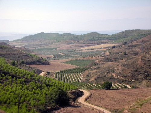
Along the path, the route may be lost several times among the edges of agricultural lands, but the village of Sansol serves as a constant reference point, always visible from the start of the stage.
Arrival in Sansol: Ascent and Panoramic View
At the first crossroads, take the right path and cross a stream. Then, access a regional road that ascends towards Sansol.
From Sansol, cross the N-111 and follow a path in a short but steep descent to the valley of the Linares River, which is crossed over a bridge. Then, enter Torres del Río. During the ascent, the Santo Sepulcro church is passed on the right, and the route continues through the village.
Crossing Torres del Río and Continuing towards Bargota
After leaving the village of Torres del Río, continue on a dirt track that ascends a slope until it almost reaches the N-111, which runs parallel on the right. The path stays very close to the road, entering it before reaching the Hermitage of the Virgen del Poyo. About 150 meters after the hermitage, leave the N-111 on the right and take a dirt track that crosses the regional road towards Bargota.
Descent towards the Mataburros Gorge
After the crossing, the track descends through the Mataburros Gorge, with the N-111 on one side and a series of vineyards, olive groves, and almond trees on the other. The path reaches the valley of the Cornava River, which is crossed before leaving behind the depopulated area of Cornava. Then, the N-111 is resumed, with the path running parallel to the road.
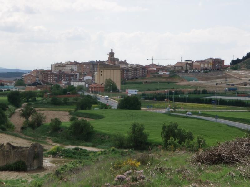
Entering Viana: End of the Stage
The route continues on the left side of the N-111 until a track leads back to the road. From there, continue along the N-111 until reaching Viana, a town that appears very close on the horizon.
Stages
- CF01 - Saint Jean de Pied de Port - Roncesvalles - 21 km
- CF02 - Roncesvalles - Zubiri - 22 km
- CF03 - Zubiri - Pamplona - 20 km
- CF04 - Pamplona - Puente la Reina - 19 km
- CF05 - Puente la Reina - Estella - 19,7 km
- CF06 - Estella - Los Arcos - 20,6 km
- CF07 - Los Arcos - Viana - 18 km
- CF08 - Viana - Navarrete - 22,3 km
- CF09 - Navarrete - Nájera - 16,9 km
- CF10 - Nájera - Santo Domingo de la Calzada - 21 km
- CF11 - Santo Domingo de la Calzada - Belorado - 22,7 km
- CF12 - Belorado - San Juan de Ortega - 24 km
- CF13 - San Juan de Ortega - Burgos - 27,6 km
- CF14 - Burgos - Hornillos del Camino - 18,3 km
- CF15 - Hornillos del Camino - Castrojeriz - 20,40 km
- CF16 - Castrojeriz - Frómista - 24,90 km
- CF17 - Frómista - Carrión de los Condes - 19,2 km
- CF18 - Carrión de los Condes - Lédigos - 23,40 km
- CF19 - Lédigos - Sahagún - 17,10 km
- CF20 - Sahagún - El Burgo Ranero - 17,9 km
- CF21 - El Burgo Ranero - Mansilla de las Mulas - 18,7 km
- CF22 - Mansilla de las Mulas - León - 18,4 km
- CF23 - León - Villadangos del Páramo - 21,8 km
- CF24 - Villadangos del Páramo - Astorga - 26 km
- CF25 - Astorga - Rabanal del Camino - 20,6 km
- CF26 - Rabanal del Camino - Molinaseca - 24,7 km
- CF27 - Molinaseca - Villafranca del Bierzo - 30,5 km
- CF28 - Villafranca del Bierzo - O Cebreiro - 30 km
- CF29 - O Cebreiro - Triacastela - 22,9 km
- CF30 - Triacastela - Sarria - 22 km
- CF31 - Sarria - Portomarín - 22 km
- CF32 - Portomarín - Palas del Rei - 23,9 km
- CF33 - Palas del Rei - Arzúa - 28,6 km
- CF34 - Arzúa - Santiago de Compostela - 38,4 km
- CF35 - O Pedrouzo - Santiago de Compostela - 20 km