
CF05 - Puente la Reina - Estella - 19,7 km
Distance20 Km.Related packages

Leaving Puente la Reina: Crossing the River Aga
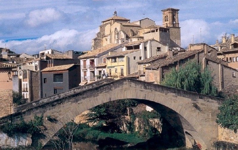
To continue the Camino de Santiago, the route begins along the Main Street of Puente la Reina until reaching the famous medieval bridge over the Aga River. Once crossed, turn left and cross the N-111 road, entering the neighbourhood of Zubiurrutia, also known as the Monjas district, where the convent of the Comendadoras del Espíritu Santo is located.
Route towards Eunea
The path continues through the settlement of Eunea, running between the Arga River on the left and the N-111 national road on the right. A comfortable dirt track is followed, which later becomes a winding and narrow path, crossing uneven land between hills and ravines.
The Camino towards Mañeru
Just before reaching Mañeru, the path turns into an authentic pilgrim’s road, a walkway parallel to the road. Crossing the streets of Mañeru leads the pilgrim to the only possible exit: Forzosa Street. On the left, the cemetery is passed, from where the village of Cirauqui can be seen on the hill ahead.
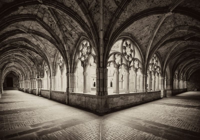
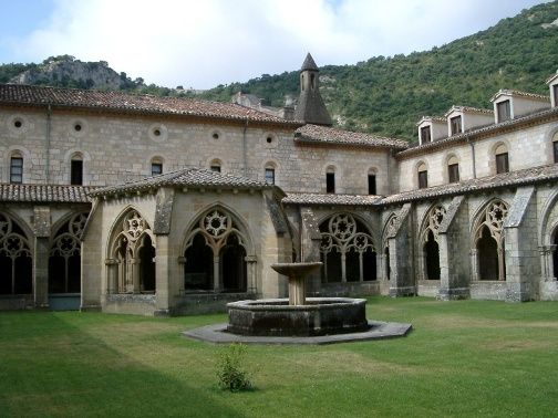
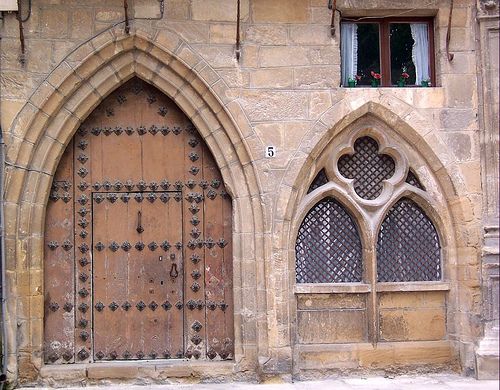
Entering Cirauqui: History and Landscape
The entrance to Cirauqui is through a beautiful ogival door. From there, the path ascends to the top of the village, then descends a steep slope, following a suggestive Roman road lined with cypress trees. The path crosses the ravine via the semi-destroyed Roman bridge, adding a historical touch to the journey.
Diverting towards the Alloz Reservoir
After crossing the national road, the path progressively diverges from it, crossing fields that once formed part of a Roman road. Just over a kilometre and a half ahead, the ancient site of Urbe is reached, situated on a hill. From here, the path descends a slope to a small country house, before emerging onto a road at the point where the turnoff to the Alloz Reservoir is located.
Ascent towards Lorca
The road is followed briefly, then left behind on the left side after passing a modern aqueduct and an old mill. After crossing the Salado River via an old bridge, the path ascends a dirt track to the village of Lorca, after crossing the N-111 via an underpass.
Towards Villatuerta and Estella
From Lorca, the path continues along the N-111, turning left just after the turnoff to Lácar and Abárzuza. The route continues along paths and fields of labour until reaching Villatuerta. From the centre of Villatuerta, the path leads towards the hermitage of San Miguel. After crossing a road and passing over a bridge across the Ega River, the path continues towards Ordoiz and finally reaches Estella, one of the key stages of the Camino de Santiago.
Stages
- CF01 - Saint Jean de Pied de Port - Roncesvalles - 21 km
- CF02 - Roncesvalles - Zubiri - 22 km
- CF03 - Zubiri - Pamplona - 20 km
- CF04 - Pamplona - Puente la Reina - 19 km
- CF05 - Puente la Reina - Estella - 19,7 km
- CF06 - Estella - Los Arcos - 20,6 km
- CF07 - Los Arcos - Viana - 18 km
- CF08 - Viana - Navarrete - 22,3 km
- CF09 - Navarrete - Nájera - 16,9 km
- CF10 - Nájera - Santo Domingo de la Calzada - 21 km
- CF11 - Santo Domingo de la Calzada - Belorado - 22,7 km
- CF12 - Belorado - San Juan de Ortega - 24 km
- CF13 - San Juan de Ortega - Burgos - 27,6 km
- CF14 - Burgos - Hornillos del Camino - 18,3 km
- CF15 - Hornillos del Camino - Castrojeriz - 20,40 km
- CF16 - Castrojeriz - Frómista - 24,90 km
- CF17 - Frómista - Carrión de los Condes - 19,2 km
- CF18 - Carrión de los Condes - Lédigos - 23,40 km
- CF19 - Lédigos - Sahagún - 17,10 km
- CF20 - Sahagún - El Burgo Ranero - 17,9 km
- CF21 - El Burgo Ranero - Mansilla de las Mulas - 18,7 km
- CF22 - Mansilla de las Mulas - León - 18,4 km
- CF23 - León - Villadangos del Páramo - 21,8 km
- CF24 - Villadangos del Páramo - Astorga - 26 km
- CF25 - Astorga - Rabanal del Camino - 20,6 km
- CF26 - Rabanal del Camino - Molinaseca - 24,7 km
- CF27 - Molinaseca - Villafranca del Bierzo - 30,5 km
- CF28 - Villafranca del Bierzo - O Cebreiro - 30 km
- CF29 - O Cebreiro - Triacastela - 22,9 km
- CF30 - Triacastela - Sarria - 22 km
- CF31 - Sarria - Portomarín - 22 km
- CF32 - Portomarín - Palas del Rei - 23,9 km
- CF33 - Palas del Rei - Arzúa - 28,6 km
- CF34 - Arzúa - Santiago de Compostela - 38,4 km
- CF35 - O Pedrouzo - Santiago de Compostela - 20 km